Exporting from your planner.
Routehold follows the exact route you give it. The best file to bring is a track: the full, road-by-road shape of your route, saved as GPX or KML/KMZ. Most planners can produce one. Here is how, app by app.
The one ruleWhen your planner offers a choice, pick Track (sometimes called "follow the exact route") over Route. A track carries your precise roads; a route carries only waypoints that get recalculated. If your file has only waypoints and no track, Routehold will offer to build a route through them on import.
MyRouteApp Save as → GPX 1.1 or 1.2
MyRouteApp's two kinds of point do exactly the two jobs Routehold cares about.
Shaping points
The MyRouteApp pin symbol
Drop these to pull the route onto the exact roads you want to ride. Routehold follows the finished route, so shaping points are simply how you choose your roads. You will not see them in Routehold: their job is done once the route is drawn.
Via points
The MyRouteApp hand symbol
Mark the places you actually want to visit: petrol stations, cafés, viewpoints. Every via point becomes a waypoint in Routehold.
Export. Save as GPX 1.1 or GPX 1.2. Both work: each carries the MyRouteApp track and your via points, and Routehold follows the track and ignores shaping points either way.
What Routehold does on import. It follows the entire track as the exact route to ride, road for road; turns each via point into a Routehold waypoint; and ignores the shaping points, which have already shaped the route.
On the ride. Every waypoint except the last auto-skips: you ride past it without touching the phone, and the voice carries on. Want to break somewhere? Mark that waypoint as a stop point and Routehold holds you there, guiding you back until you choose to move on.
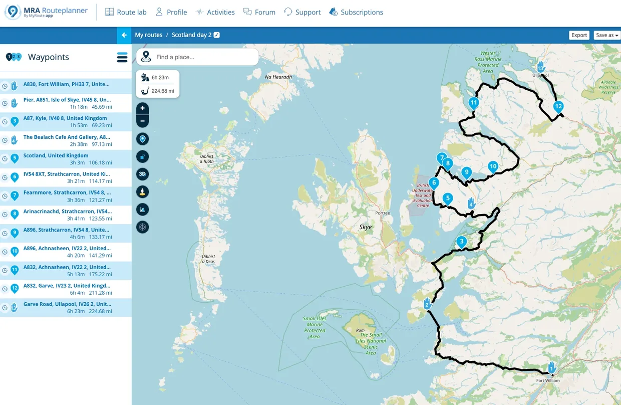
| MyRouteApp point | Type | In Routehold |
|---|---|---|
| 1 · Fort William | Via | Waypoint (start) |
| 2 · Pier, Isle of Skye | Via | Waypoint (auto-skips as you pass) |
| 4 · The Bealach Cafe | Via | Waypoint: mark as a stop to break here |
| 3, and 5 to 12 | Shaping | Not shown: they draw the exact route |
| 13 · Garve Road, Ullapool | Via | Waypoint (destination) |
Kurviger Export GPX → Track
- Open your route and choose
Export→GPX. - Select the
Trackoption ("your device follows the exact route").
Tip: Track gives Routehold your exact route: add any café or fuel stops in Routehold afterwards. Prefer Route only if you would rather bring your waypoints and let Routehold rebuild the route.
Calimoto Export GPX (Premium)
- Open your planned route in the web Trip Planner (or the app).
- Export as
GPX. (Export is a Calimoto Premium feature.)
Heads-up: Calimoto sends a dense set of route points rather than a track, so Routehold lays your route onto the roads as you import. For long trips (~400 km+), split into day sections before exporting so the route stays true.
Scenic Export GPX (Premium)
- Open the route in the app.
- Choose
Export GPXand share it to Routehold. (Scenic Premium.)
Why: Scenic's GPX includes the calculated route, which Routehold follows road-for-road.
REVER Website → Download GPX
- Open the ride on the
rever.cowebsite: the phone app can't export. - Choose
Download / Export GPX(pick a Track if offered). Export needs REVER Pro.
Tip: On a phone, open rever.co in your browser rather than the app.
Google Maps Paste into Routehold
Routehold imports Google Maps routes directly, with no converter needed.
- In Google Maps, plan your route by adding your destinations.
- Tap the Share / Copy link icon (or copy the URL from your browser).
- In Routehold, tap
Paste Google Maps link, paste it, and import.
Note: a Google Maps link only contains the waypoints, not the road-by-road route, so this is the one case where Routehold builds the route rather than following it faithfully. The result may differ slightly from Google's. For an exact route, import a GPX with its track instead.
Google My Maps Export to KML/KMZ
- Open your map in My Maps on a computer (the phone app can't export).
- Build the route with
Add directionsorDraw a line, not just dropped pins. - Open the map's
⋮menu →Export to KML/KMZ. The default KMZ is fine: Routehold reads both.
Important: A map of only pins has no route. Routehold will offer to build one, but for your exact roads use a directions or drawn-line layer.
Komoot Export GPX
- Open the route on komoot.com or in the app.
- Choose
Export GPX.
Note: Komoot's file is your exact route but carries no stop points: add any stops in Routehold after importing. Exporting may need the route's region unlocked in Komoot.
RideWithGPS GPX Track, not GPX Route
- Open the route and choose
Export. - Pick
GPX Track, notGPX Route. - Optional: tick
Include POI as waypointsto bring your stops across.
Why: "GPX Route" sends only cue points that get recalculated. Always choose "GPX Track". Saving/exporting needs a paid RideWithGPS plan.
Gaia GPS Export GPX
- Open the route or track.
- Choose
Export→GPX.
Nice: Gaia keeps both the route and your waypoints: one of the cleanest files for Routehold.
onX Offroad Export GPX, not KML
- Open your route or track and choose
Export. - Choose
GPX.
Why GPX: onX's KML export downgrades a track to a plain line: GPX keeps the track intact.
Strava Export GPX
- Open the route (from Strava's route builder).
- Choose
Export GPX.
Note: Strava exports your exact route as a track with no stop points: add stops in Routehold after. Building routes needs a subscription; public routes can be downloaded free.
Garmin Tread / Explore Share a Track as GPX
- In the app, open
Library→ your route. - Tap
Share→GPX, choosing a Track for the exact route.
Tip: Share a Track object, not a Route: a Route carries Garmin's own routing that other apps recalculate.
Garmin BaseCamp Export a Track → GPX
- Select your track (or right-click a route and convert it to a track).
File→Export, and save asGPX.
Why: Exporting a Track object locks the exact roads; a Route object gets recalculated on import.
TomTom plan.tomtom.com → GPX
- Use the web planner at
plan.tomtom.com: the phone app can't export. - Open your route →
Save as→GPX.
Why GPX: A TomTom GPX imports as a track (your exact route). ITN files are treated as re-routable stops, so prefer GPX.
Tyre to Travel GPX + "Route Tracks"
- In the Windows app:
File→Save As→GPX. - Enable
Route Tracksand the newer GPX format option.
Why: "Route Tracks" writes the exact route, and the newer format keeps your via and shaping points.
Harley-Davidson Ride Planner Download GPX
- On
maps.harley-davidson.com(or the H-D app), open your ride. - Use
Download GPX.
Tip: Turn Alternate Routes off before exporting so the file keeps the path you designed.
Indian Ride Command Track – Static Line
- Export your route as
GPX, choosingTrack – Static Line(notRoute – turn-by-turn). - From the bike's display you can also copy routes to a USB drive as GPX.
Why: "Static Line" keeps your exact roads; "turn-by-turn" gets recalculated by the receiving app.
BMW Motorrad Connected Plan elsewhere
- BMW's app is built to receive routes, not export them: there is no reliable way to get a file out.
- Plan in one of the tools above and export from there.
Tip: MyRouteApp, Kurviger and Google My Maps all export cleanly and take just a minute.
Planner apps change their menus. The rule stays the same: export a GPX or KML/KMZ, and choose the Track (or "follow the exact route") option whenever you are offered one.
Still stuck getting a file out of your planner? Get in touch and we will help you sort it.