
Ride the route you planned, together.
Routehold is a navigation app for motorcyclists who plan their rides in advance and ride them with friends.
Import the route you built in your planner and Routehold follows it road for road, in the order you set, spoken turn by turn through your helmet. Share it as a ride group and everyone sees everyone else on the map.
- Platforms
- iPhone now, Android coming
- In the car
- CarPlay now, Android Auto coming
- Connectivity
- Group functions need a data connection but if you download the route all you need to navigate is GPS.
- Imports
- GPX, KML, KMZ, Google Maps links
- Ride groups
- Up to 36 riders on one route
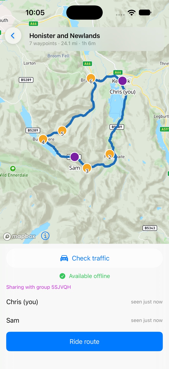
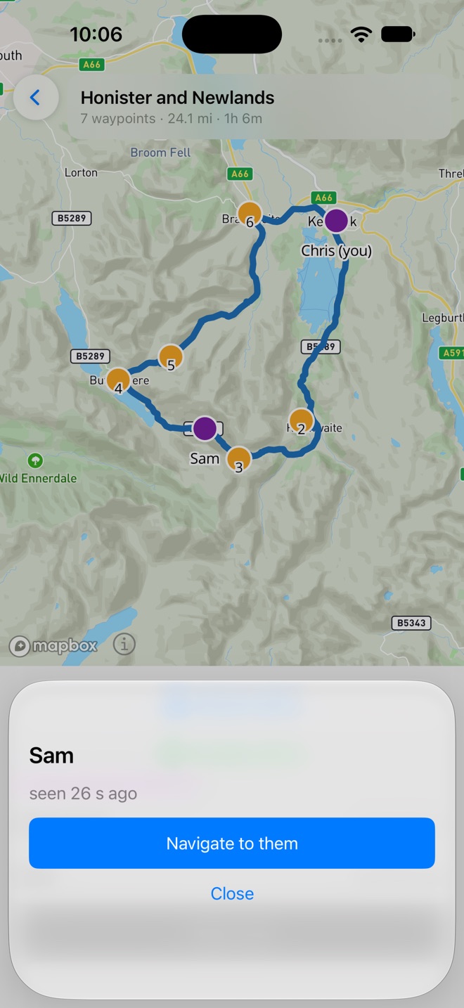
Your planner ends where the ride begins.
A rider plans a route in a tool such as MyRouteApp or Kurviger, exports it, and expects the phone to follow it faithfully.
The problem is many navigation apps don't do this - they ignore the track element of the file and recalculate the route based on your waypoints.
Routehold is different. It treats that track as the exact ride and can handle many thousands of track points, the roads you drew and the waypoints you set, in your order. Once the ride starts, the only thing you do is ride.
Share the route as a ride group before you leave, and the people you planned it with ride the same line, each seeing the others on the map.
Routehold follows the route you imported, every road and every turn, riding past each waypoint on its own with no input required from you.
Leave the route for fuel or a photo and Routehold guides you back onto it, never skipping a stop you planned and never taking a shortcut of its own.
Four steps, then you ride.
- 1 · Plan & export
- GPX, KML or KMZ
- 2 · Open in Routehold
- Waypoints numbered, distance shown
- 3 · Optionally mark waypoints as stop points
- Download for offline, then Ride
- 4 · Ride
- Routehold navigation holds you to your route precisely. You ride the route you planned, not the route your app interpreted.
Exporting from your planner is covered in the export guide.
Built for the road, not the screen.
Follows your route, road for road
Routehold rides the exact line in your import file, not a route of its own between your waypoints. It will not chase live traffic or quietly reroute you. Where a route you import leaves a gap between two points, the road Routehold chooses to fill it is drawn dotted and you are told as the ride starts, so you always know which parts of the route are yours and which were inferred. Stray from the route and Routehold guides you back onto it.
Ride with friends
Share a route as a ride group with a link or a QR code. Up to 36 riders can join, and joining opens the route on their phone, ready to download for offline use. During the ride each rider sees the others on the map, with positions updated about every twelve seconds, even with the phone in a pocket. A group that goes quiet is deleted within a day, and no account is needed.
Navigate to a friend
Someone fallen behind, or taken a wrong turn? Tap their name and Routehold guides you to them, then resumes your planned route from where they are. If they move while you ride, it re-routes to where they are now.
Fuel that is open when you get there
Press Find fuel and Routehold looks for a station ahead on your route first. It only sends you off the route when doing so saves more than fifteen miles of riding. Each station's opening hours are checked against the time you would arrive, so you are offered one that should be open when you get there. Divert to it, fill up, and press Rejoin to pick the route up again at it's closest point to you. With no route loaded, the Find fuel now button will take you to the nearest fuel stop that is estimated to be open when you get there.
Road closed? Route around it
Before you set off, Routehold checks your route for known closures and heavy traffic, and tells you how much slower it is running right now. If it finds a segment of your route is on a closed road, one press routes around every closure it knows of, asking first if one of your stop points sits on a closed road. On the ride, navigating around a closed road in front of you is one press too: Routehold takes you round it and back onto your route.
Silent waypoint progression
As you reach each waypoint, Routehold moves on to the next by itself. Nothing appears on the screen to dismiss, and nothing waits for a tap, so both hands stay on the bars while the voice carries you through to the end.
Stop points and shaping points
Mark a waypoint as a stop point, such as a café or a fuel stop, and Routehold holds you there and keeps guiding you back until you choose to move on. Leave it as a shaping point and the app passes through, or skips it if you miss it. You decide which is which before you set off.
Fully offline
Before you leave home, Routehold stores everything for the ride on the phone: the map, your route, every waypoint, and the turn-by-turn directions. Once a route is downloaded it needs nothing but a GPS signal. No mobile data, no coverage, no dead spots. Three things reach out for data when you ask for them: finding fuel, checking for closures, and ride groups.
On CarPlay and Android Auto
Connect to Apple CarPlay or Android Auto and Routehold shows your route and turn-by-turn guidance on the display. The same exact-route navigation, on the screen built into your setup.
Runs on older phones
You do not need the latest flagship. Routehold is built to run reliably on older, budget hardware, and holds itself to no more than a tenth of your phone's memory. We test on genuinely old devices, a 2020 Samsung Galaxy XCover Pro and a 2019 iPhone 11, with repeated multi-day simulated rides.
Made for the handlebars
Designed for a phone mounted on the bars. The controls are large enough for winter gloves, and the actions that matter take a deliberate press rather than an accidental swipe. The map follows the sun, light through the day and dark after sunset, and the screen stays awake for the whole ride.
Quiet by design
Routehold needs no login account, it shows no adverts and stores no analytics. It only asks for the permissions it needs to navigate and, if you join a group, to share your position with it. It stays out of the way, keeping your attention on the road ahead.
Routehold is on the App Store.
Routehold is on the App Store for iPhone, with Apple CarPlay. No login is needed. Importing, previewing and downloading routes is free. Riding, Find fuel now and ride groups need the Routehold pass. Signing up gives you a 14-day free trial; after that it converts to a subscription at £5.99 a month or £39.99 a year. Or buy Routehold Lifetime for a single payment of £119.99. Prices in other countries are set by the App Store and shown before you confirm.
The Android version, with Android Auto, is coming. Leave your email and we will tell you when it is ready.
- Platforms
- iPhone now, Android coming
- In the car
- CarPlay now, Android Auto coming
- Connectivity
- GPS only, fully offline
- Price
- 14-day free trial, then £5.99 a month, £39.99 a year or £119.99 once
We only use your email to tell you when the Android app is ready. By signing up you agree to our Terms and Privacy Policy.